Why Revisit the NACES MPA?
While the 2021 designation focused primarily on seabirds and the upper water column, emerging evidence quickly indicated that the mesopelagic and deeper zones were equally critical to the region’s ecological integrity due to the highly energetic nature of eddy activity going all the way to the seabed. In response, OSPAR Contracting Parties adopted a science-led Roadmap in 2021, launching the two-year review to assess the site using the best available data.
The revision was not only about expanding spatial boundaries; it sought to recast the conservation rationale, shifting from a surface-centric approach to a whole-ecosystem perspective. This meant recognising the ecological linkages that span from the ocean surface to the seabed, including nutrient transport, bentho-pelagic coupling, and species that depend on vertical connectivity throughout the water column.

A Complex and Productive System
The NACES site occupies a biogeographically and oceanographically dynamic region. It lies at the intersection of subtropical, subpolar, and Arctic water masses in an area of intense mesoscale activity—including eddies and frontal systems—that enhance nutrient flux, promote mixing, and support high levels of primary productivity. These physical processes underpin the area’s ecological richness, sustaining both pelagic and benthic communities.
The region features significant geodiversity, including:
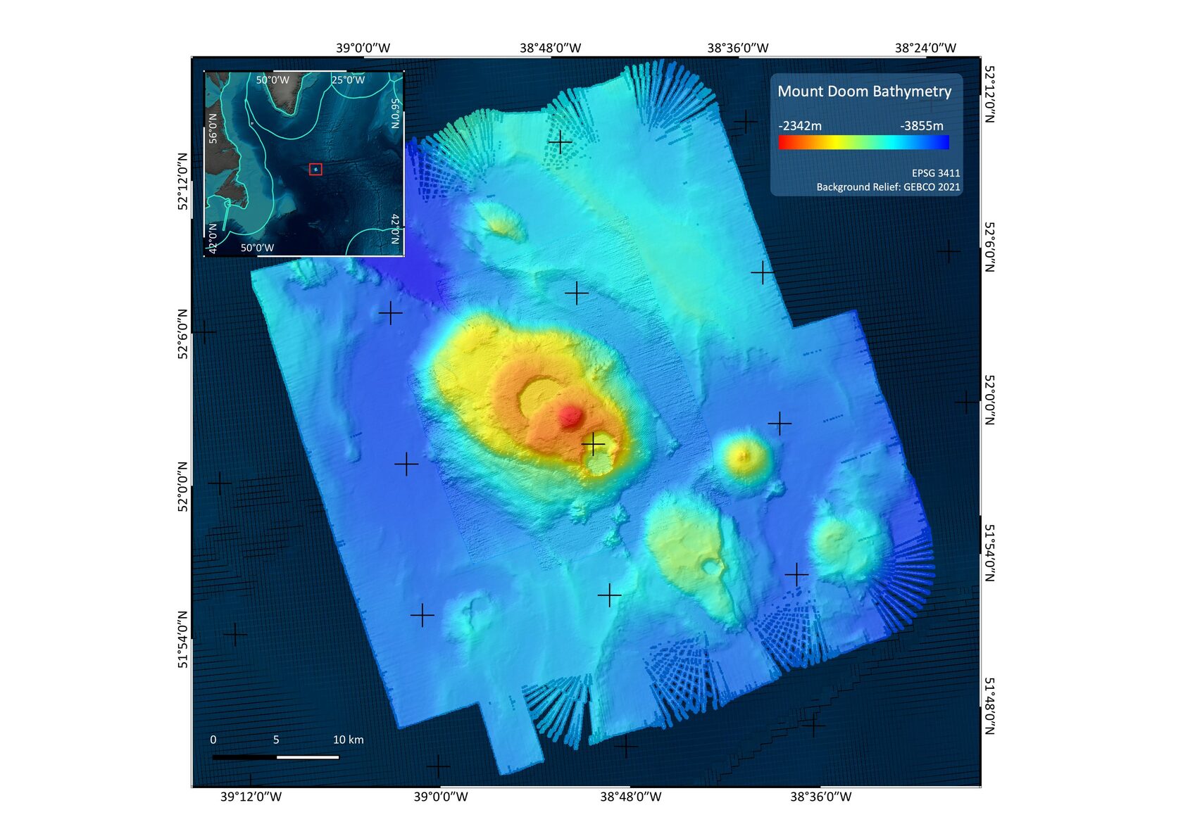
- Seamounts (~47 in total based on a combination of direct observation and modelling), among them the Evlanov Seamount and recently mapped “Mount Doom”;
- Abyssal plains and knolls, narrow canyons, escarpments; and
- Fracture zones such as the Charlie-Gibbs Fracture Zone, a key biogeographic connector between the North-East and North-West Atlantic basins.
These features in turn support a remarkable array of species and habitats of conservation concern in the OSPAR List of Threatened and/or Declining Species & Habitats, the IUCN Red List, and Vulnerable Marine Ecosystems (VMEs; defined by the FAO of the United Nations):
- Seabirds: Over 5 million individuals across more than 23 species, including OSPAR-listed black-legged kittiwake, thick-billed murre, and Macaronesian shearwater;
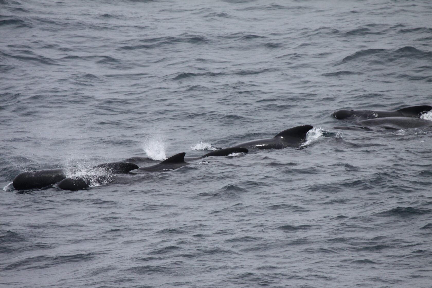
- Cetaceans: Blue, fin, and sei whales use the site for foraging and migration, supported by satellite telemetry and visual surveys;
- Highly mobile pelagic species: Atlantic bluefin tuna, leatherback and loggerhead turtles,shortfin mako, blue shark and great whites;
- Midwater fauna: Over 100 mesopelagic fish species, over 25 cephalopod species, and diverse gelatinous zooplankton, many structured by eddy systems; and
- Benthic assemblages: Deep-sea sponge and coral communities, and distinct fauna associated with the site’s seafloor features.
These interconnected systems reveal NACES as a region of exceptional ecological and functional diversity from surface productivity to seafloor complexity. However, it is also an area under pressure by tuna fisheries, shipping, subsea cables, litter and microplastics. Climate change will also impact on the physical and biological oceanography, species distributions, and the site could become an area for future resource extraction activities.

Science at the Centre
The revision process placed science firmly at the core of decision-making. The updated nomination proforma synthesised a wide range of new and existing datasets, including contributions from the EU-funded iAtlantic project, international seabed mapping expeditions, and marine ecological modelling initiatives.
Additionally, the work conducted by the team of consultants included:
- Integration of spatial data on geodiversity, benthic and pelagic habitat types, species distributions, and oceanographic features;
- Chairing international workshops, literature synthesis and expert analysis to support an expanded set of conservation features;
- Technical drafting and co-authorship of the revised nomination text;
- Evidence-based contributions to stakeholder consultation and communication processes.
A subset of the resulting datasets, now publicly available on PANGAEA, offer one of the most comprehensive compilations to date on the geophysical and ecological characteristics of this region. They confirm NACES as a seamount and biodiversity hotspot for both Atlantic migratory species and mesopelagics, including populations at the northern or depth-related limits of their known ranges.
A Revised Conservation Vision
Based on this strong scientific evidence base, the OSPAR Commission adopted an amending decision in June 2023 that formally broadened the scope of the NACES MPA. The revised designation now includes:
- Explicit protections for the seabed and subsoil, complementing the existing focus on surface waters;
- A significantly expanded set of ecosystems, habitats, and species, including both OSPAR-listed features and non-listed taxa of ecological importance; and
- Conservation objectives aimed at maintaining ecological processes such as nutrient cycling, energy flow, and bentho-pelagic coupling.
This marks the first full revision of an OSPAR MPA where the majority of the area is beyond national jurisdiction (ABNJ) and it sets an important precedent for adaptive, science-informed management.
Towards the Future of Ocean Governance
The NACES MPA revision demonstrates what can be achieved when robust scientific evidence informs international decision-making. It highlights the vital role of coordinated science-policy interfaces in implementing meaningful protection. As efforts continue under the new BBNJ Agreement, the NACES case provides a working model for how area-based management tools (ABMTs) can be designed and refined, with the next challenge focusing on implementation and management. It is both a successful outcome and a blueprint for future science-driven marine protection in areas within and beyond national jurisdiction.